 국립중앙도서관 "우편 복사 서비스"로 연결 됩니다.

 KCI
KCI 스콜라
스콜라임진강유역은 고구려의 남쪽 경계선으로 남진정책이후 멸망할 때까지 공격과 방어의 背後基地로서 역할을 수행하였다. 이는 임진강유역의 고구려 관방체계가 철저한 지형분석을 ...
다국어 입력
あ
ぁ
か
が
さ
ざ
た
だ
な
は
ば
ぱ
ま
や
ゃ
ら
わ
ゎ
ん
い
ぃ
き
ぎ
し
じ
ち
ぢ
に
ひ
び
ぴ
み
り
う
ぅ
く
ぐ
す
ず
つ
づ
っ
ぬ
ふ
ぶ
ぷ
む
ゆ
ゅ
る
え
ぇ
け
げ
せ
ぜ
て
で
ね
へ
べ
ぺ
め
れ
お
ぉ
こ
ご
そ
ぞ
と
ど
の
ほ
ぼ
ぽ
も
よ
ょ
ろ
を
ア
ァ
カ
サ
ザ
タ
ダ
ナ
ハ
バ
パ
マ
ヤ
ャ
ラ
ワ
ヮ
ン
イ
ィ
キ
ギ
シ
ジ
チ
ヂ
ニ
ヒ
ビ
ピ
ミ
リ
ウ
ゥ
ク
グ
ス
ズ
ツ
ヅ
ッ
ヌ
フ
ブ
プ
ム
ユ
ュ
ル
エ
ェ
ケ
ゲ
セ
ゼ
テ
デ
ヘ
ベ
ペ
メ
レ
オ
ォ
コ
ゴ
ソ
ゾ
ト
ド
ノ
ホ
ボ
ポ
モ
ヨ
ョ
ロ
ヲ
―
http://chineseinput.net/에서 pinyin(병음)방식으로 중국어를 변환할 수 있습니다.
변환된 중국어를 복사하여 사용하시면 됩니다.
예시)
- 中文 을 입력하시려면 zhongwen을 입력하시고 space를누르시면됩니다.
- 北京 을 입력하시려면 beijing을 입력하시고 space를 누르시면 됩니다.
А
Б
В
Г
Д
Е
Ё
Ж
З
И
Й
К
Л
М
Н
О
П
Р
С
Т
У
Ф
Х
Ц
Ч
Ш
Щ
Ъ
Ы
Ь
Э
Ю
Я
а
б
в
г
д
е
ё
ж
з
и
й
к
л
м
н
о
п
р
с
т
у
ф
х
ц
ч
ш
щ
ъ
ы
ь
э
ю
я
′
″
℃
Å
¢
£
¥
¤
℉
‰
$
%
F
₩
㎕
㎖
㎗
ℓ
㎘
㏄
㎣
㎤
㎥
㎦
㎙
㎚
㎛
㎜
㎝
㎞
㎟
㎠
㎡
㎢
㏊
㎍
㎎
㎏
㏏
㎈
㎉
㏈
㎧
㎨
㎰
㎱
㎲
㎳
㎴
㎵
㎶
㎷
㎸
㎹
㎀
㎁
㎂
㎃
㎄
㎺
㎻
㎽
㎾
㎿
㎐
㎑
㎒
㎓
㎔
Ω
㏀
㏁
㎊
㎋
㎌
㏖
㏅
㎭
㎮
㎯
㏛
㎩
㎪
㎫
㎬
㏝
㏐
㏓
㏃
㏉
㏜
㏆

RISS 인기검색어

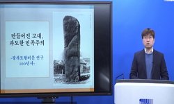
南韓地域 高句麗 關防體系 - 臨津江流域을 중심으로 = The Military Defense System of Goguryeo Period in South Korea - Centering of the Imjin River Basin -
한글로보기https://www.riss.kr/link?id=A76459092
- 저자
- 발행기관
- 학술지명
- 권호사항
-
발행연도
2007
-
작성언어
-
-
주제어
고구려 ; 남진정책 ; 관방체계 ; 성곽 ; 보루 ; 임진강 ; 한강 ; 하천로 ; 기와 ; Goguryeo Kingdom ; Southward Extension Policy ; Military Defense System ; Castle ; Fortress ; Imjin River ; Han River ; Water Road ; Roof Tiles
-
KDC
911
-
등재정보
KCI등재후보
-
자료형태
학술저널
-
수록면
279-306(28쪽)
-
KCI 피인용횟수
20
- DOI식별코드
- 제공처
-
0
상세조회 -
0
다운로드
부가정보
국문 초록 (Abstract)
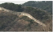
임진강유역은 고구려의 남쪽 경계선으로 남진정책이후 멸망할 때까지 공격과 방어의 背後基地로서 역할을 수행하였다. 이는 임진강유역의 고구려 관방체계가 철저한 지형분석을 통하여 치밀한 계획하에 설계되었으며, 하천과 교통로를 중심으로 효율적인 관방체계를 구축할 수 있도록 추진되었기 때문에 가능하였다.<BR> 먼저 임진강 북안에는 강안과 접하여 據點城과 衛城堡壘가 組合關係를 이루며 북동-남서방향을 중심축으로 하는 線上防禦體系를 형성하였다. 임진강과 한탄강의 합류지역에는 동서교통로와 남북교통로가 교차하고 있으며 이곳에 성곽을 능형의 평면형태로 배치하는 菱形防禦體系를 구축하였다. 이 체계는 양주분지와 천보산맥일원에서 능형내곽보루군과 환상외곽보루군을 이루는 ??峰形의 입체적인 방어체계로 완성되었다고 할 수 있다.<BR> 거점성은 임진강유역의 자연환경적 요소를 철저하게 이용한 은대리성과 당포성, 호루고루 등과 같은 二等邊三角形의 江岸平地城이 그 역할을 담당하였고, 여기에 소규모의 위성보루를 배치하는 독특한 구조를 하였다. 그 중 호로고루를 중심으로 한 거점성과 위성보루의 관계, 하천을 사이에 둔 대응관계, 삼각형 구도의 배치, 산성의 전방배치 등은 삼국시대 관방체계의 전형을 보여준다고 할 수 있다. 이러한 북안의 조합관계를 모태로 남안에서는 거점성을 시발점으로 남진하는 河川路의 동안이나 서안에 칠중성, 아미성, 대전리산성 등의 산성을 배치하여 이를 남진로의 교두보로 이용하였다. 북쪽에서 내려오는 하천로는 이들 거점성을 거쳐야만 천보산맥일원을 거쳐 한강유역으로 진출할 수 있다. 그 주요 하천로는 신천로, 간파천로, 설마 천로, 문산천로, 포천천로 등 5개 노선으로 추정하였다.<BR> 한편 기와류는 임진강유역의 고구려성곽에서 집중적으로 출토되었다. 그 분포는 임진ㆍ한탄강의 합류지역과 호로고루 주변의 성곽, 하천로변의 남안 성곽에서 출토되고 있다. 이는 한강유역이나 천보산맥 일원과는 달리 임진강유역 고구려 성곽의 위상을 말해주는 것임과 동시에 그 사용시기가 오랫동안 지속되었음을 알 수 있게 한다.
임진강유역은 고구려의 남쪽 경계선으로 남진정책이후 멸망할 때까지 공격과 방어의 背後基地로서 역할을 수행하였다. 이는 임진강유역의 고구려 관방체계가 철저한 지형분석을 통하여 치밀한 계획하에 설계되었으며, 하천과 교통로를 중심으로 효율적인 관방체계를 구축할 수 있도록 추진되었기 때문에 가능하였다.<BR> 먼저 임진강 북안에는 강안과 접하여 據點城과 衛城堡壘가 組合關係를 이루며 북동-남서방향을 중심축으로 하는 線上防禦體系를 형성하였다. 임진강과 한탄강의 합류지역에는 동서교통로와 남북교통로가 교차하고 있으며 이곳에 성곽을 능형의 평면형태로 배치하는 菱形防禦體系를 구축하였다. 이 체계는 양주분지와 천보산맥일원에서 능형내곽보루군과 환상외곽보루군을 이루는 ??峰形의 입체적인 방어체계로 완성되었다고 할 수 있다.<BR> 거점성은 임진강유역의 자연환경적 요소를 철저하게 이용한 은대리성과 당포성, 호루고루 등과 같은 二等邊三角形의 江岸平地城이 그 역할을 담당하였고, 여기에 소규모의 위성보루를 배치하는 독특한 구조를 하였다. 그 중 호로고루를 중심으로 한 거점성과 위성보루의 관계, 하천을 사이에 둔 대응관계, 삼각형 구도의 배치, 산성의 전방배치 등은 삼국시대 관방체계의 전형을 보여준다고 할 수 있다. 이러한 북안의 조합관계를 모태로 남안에서는 거점성을 시발점으로 남진하는 河川路의 동안이나 서안에 칠중성, 아미성, 대전리산성 등의 산성을 배치하여 이를 남진로의 교두보로 이용하였다. 북쪽에서 내려오는 하천로는 이들 거점성을 거쳐야만 천보산맥일원을 거쳐 한강유역으로 진출할 수 있다. 그 주요 하천로는 신천로, 간파천로, 설마 천로, 문산천로, 포천천로 등 5개 노선으로 추정하였다.<BR> 한편 기와류는 임진강유역의 고구려성곽에서 집중적으로 출토되었다. 그 분포는 임진ㆍ한탄강의 합류지역과 호로고루 주변의 성곽, 하천로변의 남안 성곽에서 출토되고 있다. 이는 한강유역이나 천보산맥 일원과는 달리 임진강유역 고구려 성곽의 위상을 말해주는 것임과 동시에 그 사용시기가 오랫동안 지속되었음을 알 수 있게 한다.
다국어 초록 (Multilingual Abstract)
The Imjin River basin was the south boundary of the Goguryeo Kingdom and was the hinterland during attacks and as a defense since its Southward Extension Policy until Goguryeo was destroyed. It was possible because the military defense system around the Imjin River basin had been designed according to strict plans through thorough geographical analysis and built to form an effective military system centering on the river and transportation roads.<BR> First of all, the north bank of the Imjin River adjoined the riverbank. The stronghold castle and defense fort were built as a coordinate along the northeast and southwest direction, respectively and that formed a defense system along the riverside area. At the junction where the Imjin River and the Hantan River merged, the east-west transportation road and the south-north transportation road were exchanged and a lozenge-shaped defense system was built and fortresses were assigned at each angle. This system was a pot-shaped cubic defense system of which the inside fortress was lozenge-shaped and the outer fortress was ring-shaped along the Yangju Basin and the Chunbo Mountain Range.<BR> A castle on the plain area of the riverbank took on therole of a key station castle and it includes Eundaeri Castle, Danpo Castle, and the Horogoru Fortress that were located in the form of an isosceles triangle. They utilized natural environmental elements of the Imjin River basin thoroughly. Among them, the relationship between the key station castles centering around the Horo goru Fortress and the defense fortresses, their confrontational position with the river in between, the triangle layout, and the fortress in the front line all those showed the typical properties of a defense system in the Era of the Three Kingdoms. Based on the coordination of the fortresses on the north bank, the fortresses such as Chiljung Fortress, Ami Fortress, and Daejeonri Fortress were built on the east bank or west bank of the river road flowing to the south from the key station fortress. They were used as a beachhead for the southward road. The river road running from the north ran into the Han River through the Chunbo Mountain Range and ran past and through these fortresses. It is suspected that there were 5 major river roads including Chinchun-ro, Ganpacheon-ro, Seolmacheon-ro, Munsancheon-ro, and Pocheonchun-ro.<BR> By the way, roof tiles were mainly found in the castles of the Goguryeo Kingdom in the Imjin River basin. The locations are the junction area of the Imjin River and the Hantan River, a fortress near the Horogoru Fortress, and the fortress on the south bank near the river roads. This shows the critical status of the castles of the Goguryeo Kingdom in the Imjin River basin, unlike those in the Han River basin or the area around the Cheonbo Mountain Range, as well as the fact that they had been used for a long time.
The Imjin River basin was the south boundary of the Goguryeo Kingdom and was the hinterland during attacks and as a defense since its Southward Extension Policy until Goguryeo was destroyed. It was possible because the military defense sys...
The Imjin River basin was the south boundary of the Goguryeo Kingdom and was the hinterland during attacks and as a defense since its Southward Extension Policy until Goguryeo was destroyed. It was possible because the military defense system around the Imjin River basin had been designed according to strict plans through thorough geographical analysis and built to form an effective military system centering on the river and transportation roads.<BR> First of all, the north bank of the Imjin River adjoined the riverbank. The stronghold castle and defense fort were built as a coordinate along the northeast and southwest direction, respectively and that formed a defense system along the riverside area. At the junction where the Imjin River and the Hantan River merged, the east-west transportation road and the south-north transportation road were exchanged and a lozenge-shaped defense system was built and fortresses were assigned at each angle. This system was a pot-shaped cubic defense system of which the inside fortress was lozenge-shaped and the outer fortress was ring-shaped along the Yangju Basin and the Chunbo Mountain Range.<BR> A castle on the plain area of the riverbank took on therole of a key station castle and it includes Eundaeri Castle, Danpo Castle, and the Horogoru Fortress that were located in the form of an isosceles triangle. They utilized natural environmental elements of the Imjin River basin thoroughly. Among them, the relationship between the key station castles centering around the Horo goru Fortress and the defense fortresses, their confrontational position with the river in between, the triangle layout, and the fortress in the front line all those showed the typical properties of a defense system in the Era of the Three Kingdoms. Based on the coordination of the fortresses on the north bank, the fortresses such as Chiljung Fortress, Ami Fortress, and Daejeonri Fortress were built on the east bank or west bank of the river road flowing to the south from the key station fortress. They were used as a beachhead for the southward road. The river road running from the north ran into the Han River through the Chunbo Mountain Range and ran past and through these fortresses. It is suspected that there were 5 major river roads including Chinchun-ro, Ganpacheon-ro, Seolmacheon-ro, Munsancheon-ro, and Pocheonchun-ro.<BR> By the way, roof tiles were mainly found in the castles of the Goguryeo Kingdom in the Imjin River basin. The locations are the junction area of the Imjin River and the Hantan River, a fortress near the Horogoru Fortress, and the fortress on the south bank near the river roads. This shows the critical status of the castles of the Goguryeo Kingdom in the Imjin River basin, unlike those in the Han River basin or the area around the Cheonbo Mountain Range, as well as the fact that they had been used for a long time.
목차 (Table of Contents)
- 【국문초록】
Ⅰ. 머리말
Ⅱ. 臨津江流域의 高句麗 城郭
Ⅲ. 臨津江流域 高句麗 城郭의 特徵
Ⅳ. 臨津江流域의 高句麗 關防體系
Ⅴ. 맺는말
【參考文獻】
- 【국문초록】
Ⅰ. 머리말
Ⅱ. 臨津江流域의 高句麗 城郭
Ⅲ. 臨津江流域 高句麗 城郭의 特徵
Ⅳ. 臨津江流域의 高句麗 關防體系
Ⅴ. 맺는말
【參考文獻】
참고문헌 (Reference)
1 "臨津江流域 高句麗 평기와 硏究" 韓國文化史學會 21 : 2004
2 "臨津江漢灘江 北岸의 關防遺蹟 임진강" 경기도박물관 2001
3 "臨津江 南岸一帶의 關防遺蹟 임진강" 경기도박물관 2001
4 "漣川 瓠蘆古壘 精密地表調査報告書" 1999
5 "漣川 瓠蘆古壘 2次發掘調査略報告書" 2006
6 "漣川 瓠蘆古壘 1次發掘調査略報告書" 2001
7 "파주시의 역사와 문화유적" 1999
8 "파주 칠중성 지표조사보고서" 2001
9 "파주 덕진산성 시굴조사" 2004
10 "임진강 경기3대 하천유역 종합학술조사Ⅰ" 2000
1 "臨津江流域 高句麗 평기와 硏究" 韓國文化史學會 21 : 2004
2 "臨津江漢灘江 北岸의 關防遺蹟 임진강" 경기도박물관 2001
3 "臨津江 南岸一帶의 關防遺蹟 임진강" 경기도박물관 2001
4 "漣川 瓠蘆古壘 精密地表調査報告書" 1999
5 "漣川 瓠蘆古壘 2次發掘調査略報告書" 2006
6 "漣川 瓠蘆古壘 1次發掘調査略報告書" 2001
7 "파주시의 역사와 문화유적" 1999
8 "파주 칠중성 지표조사보고서" 2001
9 "파주 덕진산성 시굴조사" 2004
10 "임진강 경기3대 하천유역 종합학술조사Ⅰ" 2000
11 "연천군의 역사와 문화유적" 2000
12 "연천 은대리성 지표 및 시발굴조사 보고서" 2004
13 "연천 당포성 지표 및 발굴조사" 2003
14 "연천 당포성 2차 발굴조사" 2006
15 "신라육상교통로연구" 학연문화사 1999
16 "배천산성 답사보고 고고민속" 사회과학원 고고학민속학연구소 25-, 1996
17 "남한지역의 고구려 유적 고구려 유적 발굴과 유물" 고구려연구회 2001
18 "남한지역의 고구려 성곽 한국 고대의 Global Pride 고구려" 고려대학교 박물관 2005a
19 "남한지역 고구려 城堡와 관련된 문제와 성격의 검토 九里高句麗國際學術會議" 구리문화원 2000
20 "남한의 고구려유적" 2007
21 "남한의 고구려 유적과 유물" 한국고대사학회 2004
22 "군사보호구역 문화유적 지표조사 보고서" 2000
23 "高句麗 國內城期 평기와 考察" 韓國文化史學會 25 : 2006b
24 "百濟城郭의 比較硏究試論 百濟論叢 5" 百濟文化開發硏究院 1996
25 "百濟 漢城期 六溪土城에 대하여 國立公州博物館紀要 5" 2006a
26 "漢江北岸 高句麗 堡壘의 築造時期와 그 性格" 서울大學校 碩士學位論文 2001
27 "最近 發見 京畿地域 高句麗 遺蹟 北方史論叢" 고구려연구재단 2005b
28 "坡州 六溪土城" 2006
29 "坡州 舟月里遺蹟" 1999
30 "北韓 境內의 高句麗 山城 分布와 硏究現況 高句麗 山城과 防禦體系" 高句麗硏究會 1999
31 "京畿道 漣川郡 軍事遺蹟 地表調査報告書" 1995
32 "京畿地域의 鄕土文化 下" 1997
33 "京畿北部地域의 高句麗 關防體系 高句麗山城과 關防體系" 高句麗硏究會 1999
34 "京畿北部地域 高句麗 堡壘 考察 文化史學 17" 韓國文化史學會 2002
35 "京畿北部地域 高句麗 城郭의 分布와 性格" 3 : 1999
36 "The Military Defense System of Goguryeo Period in South Korea"
37 "The Imjin River basin was the south boundary of the Goguryeo Kingdom and was the hinterland during attacks and as a defense since its Southward Extension Policy until Goguryeo was destroyed It was possible because the military defense system around the Imjin River basin had been designed according to strict plans through thorough geographical analysis and built to form an effective military system centering on the river and transportation roads"
38 "First of all, the north bank of the Imjin River adjoined the riverbank. The stronghold castle and defense fort were built as a coordinate along the northeast and southwest direction, respectively and that formed a defense system along the riverside area. At the junction where the Imjin River and the Hantan River merged, the east-west transportation road and the south-north transportation road were exchanged and a lozenge-shaped defense system was built and fortresses were assigned at each angle. This system was a pot-shaped cubic defense system of which the inside fortress was lozenge-shaped a"
39 "By the way, roof tiles were mainly found in the castles of the Goguryeo Kingdom in the Imjin River basin. The locations are the junction area of the Imjin River and the Hantan River, a fortress near the Horogoru Fortress, and the fortress on the south bank near the river roads. This shows the critical status of the castles of the Goguryeo Kingdom in the Imjin River basin, unlike those in the Han River basin or the area around the Cheonbo Mountain Range, as well as the fact that they had been used for a long time."
40 "A castle on the plain area of the riverbank took on therole of a key station castle and it includes Eundaeri Castle, Danpo Castle, and the Horogoru Fortress that were located in the form of an isosceles triangle. They utilized natural environmental elements of the Imjin River basin thoroughly. Among them, the relationship between the key station castles centering around the Horo goru Fortress and the defense fortresses, their confrontational position with the river in between, the triangle layout, and the fortress in the front line all those showed the typical properties of a defense system in"
41 "6~7世紀 高句麗 南境 考察 고구려연구 11" 고구려연구회 2001
42 "- Centering of the Imjin River Basin -"
동일학술지(권/호) 다른 논문
-
- 한국고대학회
- 백종오 ( Jong Oh Baek )
- 2006
- KCI등재후보
-
한국고대의 토기문화 ; 청주지역 원삼국~백제시대 생활유적 토기 상대편년 연구
- 한국고대학회
- 조상기 ( Sang Gi Cho )
- 2006
- KCI등재후보
-
한국고대의 토기문화 ; 한강류역(漢江流域) 신라(新羅) 토기(土器)의 성격(性格)
- 한국고대학회
- 강진주 ( Jin Joo Kang )
- 2006
- KCI등재후보
-
백제(百濟) 한성기(漢城期) 관방체계(關防體系) 검토(檢討)
- 한국고대학회
- 오강석 ( Kang Suk Oh )
- 2006
- KCI등재후보
분석정보
인용정보 인용지수 설명보기
학술지 이력
| 연월일 | 이력구분 | 이력상세 | 등재구분 |
|---|---|---|---|
| 2027 | 평가예정 | 재인증평가 신청대상 (재인증) | |
| 2021-01-01 | 평가 | 등재학술지 유지 (재인증) |  |
| 2018-01-01 | 평가 | 등재학술지 유지 (등재유지) | |
| 2015-01-01 | 평가 | 등재학술지 유지 (등재유지) | |
| 2011-01-01 | 평가 | 등재학술지 유지 (등재유지) | |
| 2008-01-01 | 평가 | 등재학술지 선정 (등재후보2차) | |
| 2007-01-01 | 평가 | 등재후보 1차 PASS (등재후보1차) |  |
| 2005-01-01 | 평가 | 등재후보학술지 선정 (신규평가) | |
학술지 인용정보
| 기준연도 | WOS-KCI 통합IF(2년) | KCIF(2년) | KCIF(3년) |
|---|---|---|---|
| 2016 | 0.59 | 0.59 | 0.61 |
| KCIF(4년) | KCIF(5년) | 중심성지수(3년) | 즉시성지수 |
| 0.59 | 0.56 | 1.438 | 0.17 |


이 자료와 함께 이용한 RISS 자료
나만을 위한 추천자료


